Showing posts with label Cloneshouse Nigeria. Show all posts

Monday, April 22, 2013

MONITORING AND EVALUATION SYSTEMS: CAN THEY PROMOTE TRANSPARENCY AND ACCOUNTABILITY IN WEST AFRICA?


Development programs are expected to deliver results for everyone involved in development. The value of their ideas, advice and action produced is increasingly being gauged by whether it improves lives and 
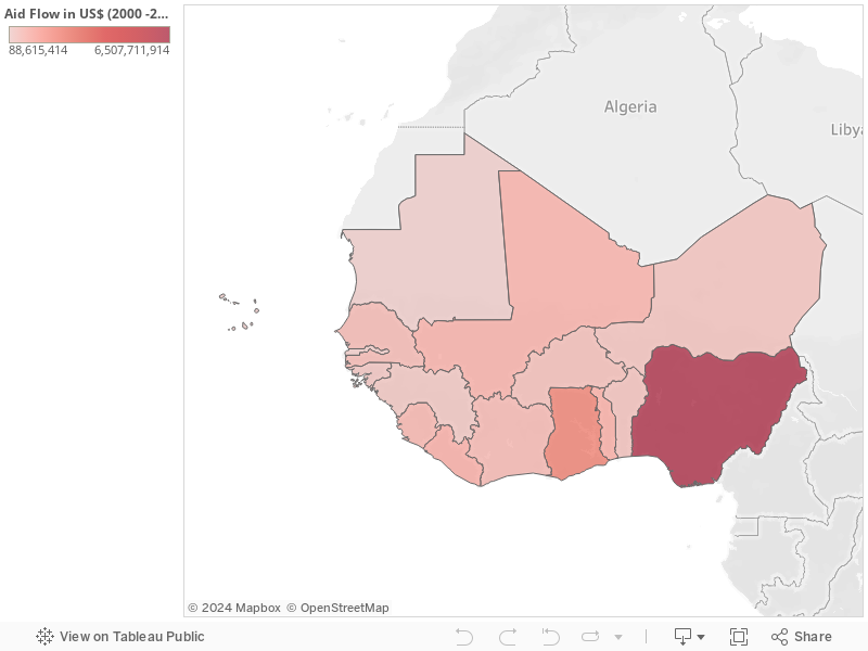
for us to affirm, it should be in the public domain. In the 16 countries in West Africa alone, $15 trillion has been spent on aid between 2010 – 2012 with Nigeria and Ghana receiving the most with 42% and 14% respectively (View the dataset Here). Lots of funds you will say – but does this amount to development? Out rightly, only two 
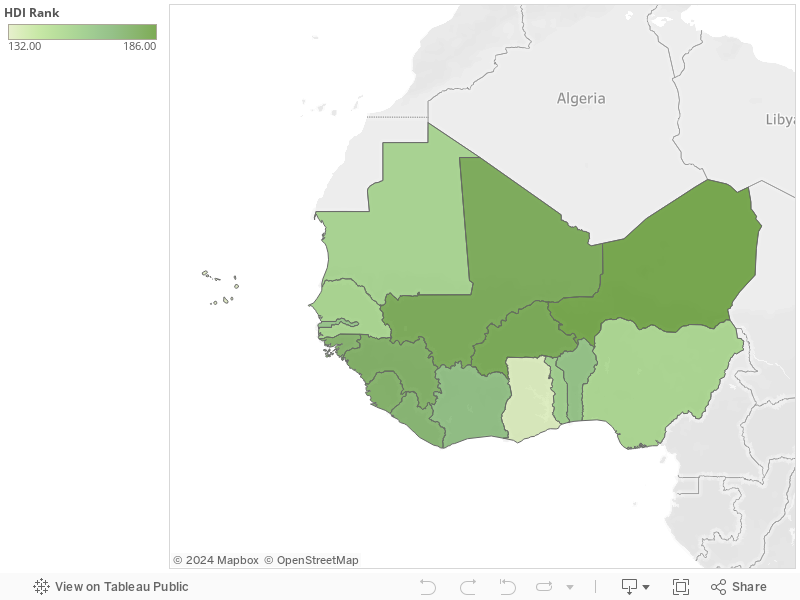
(Cape Verde and Ghana) out of these 16 countries falls within the Medium Human Development Rank of the Human Development Index 2013, the others keep crawling within the Low Human Development Rank since 2009 that the Index has been published.


Consequently, every program needs the information to answer three vital questions: “what could constitute success in addressing problems?”; “How will we know success when we achieve it”? And can achievements and its processes be shared in the public domain”? Monitoring and Evaluation (M&E) systems can help everyone understand which programs are working, which are not, which can be scaled up, and which could be abandoned, but how it answers the questions in these West African countries remain farfetched!

Recently, during one of the M&E courses I facilitated with Cloneshouse Nigeria, where 80% participants were from government institutions, I asked “will your government be able to publish findings in public domain, or perhaps the breakdown of total spending of your government”? Most of them responded with enthusiasm that they are willing and ready, but their greatest fear might be hindrances coming from the political party, on whose platform they were elected.
Problems of the Country highlighted in Red and Solutions in Green. How True?


Nevertheless, M&E systems can promote transparency and accountability within governments in West Africa. Beneficial spillover effects may also occur from shining a light on results. For aid organizations, how much pressure is put on receiving governments is what we don’t know. One of the participants asked “why do we always receive world bank grants for creation of more health centers, while the once available aren't serving to optimal level, we already have enough health centers to cater for the population of the state”


No doubt, external and internal stakeholders should have a clear sense of status of projects, programs and policies. But, is the ability to demonstrate positive results able to increase popular and political support in West Africa? The truth is that most citizens do not have public confidence in the leadership of their various states. Even, if they publish positive results, citizens believe the outcomes are been doctored to portray “a breath of fresh air” which evaporates at dawn.

Certainly, there are organizational and political costs, and risk associated with implementing result – based M&E systems. There are also crucial costs and risks in not implementing such systems. Suffice it to say that, M&E systems are not new to governments in West Africa, with every department and project having its own M&E unit – how effective are the unit in this region? Permit me to say “I only see their trucks and vehicles, much more than I see their findings in the public domain.

Tuesday, October 2, 2012

WHEN THE GOOGLE MAP MAKER AFRICAN REGIONAL CONFERENCE WAS HELD IN LAGOS


Attending conferences in Lagos can be ecthic a times,  but it might be strategic for technology based conferences, in that most tech hubs and institutions are based in Lagos. Much reason why Lagos has the most populated points on Google Maps. While for me, August 24 – 25, 2012 was a good date, reason been it was just on the last day the Cloneshouse Nigeria's Monitoring & Evaluation Lagos training will be ending. After 5days of course facilitation, heading to another conference might be interesting.
Cross section of participants at the Conference

The reception at the Victoria Crown Plaza Hotel on Victoria Island looks fascinating, and perhaps, it might be a 2days of rest. They have gotten some great facilities in their room. Entering, all I needed to do was to connect to the internet – it was exceptionally fast! Immediately I had to check where that network was from – MainOne Cable did the Job! A downloading speed at about 2mb/sec, none have seen like that in Nigeria. Maybe, a good reason why Evans, and the Google Map Maker team chose this location for the Africa Regional Conference.


Kicking off the keynote session was Jayanth Mysore, who presented how Google Maps have evolved over time -  From 22 countries (13million miles) in 2008 to about 187 countries (26million miles) in 2012. He emphasized on how all this data has been generated – (1) Ground Truth, which is an internal effort (Google Map Maker offices); (2) Contributions from Google Map users; (3) Google Place for Business where you add your business location and information of owner; (4) Data from Governments and Agencies where Google buys licenses from these organizations.
Jayanth Mysore - The Keynote Speaker at the conference

As the participants needed to know how the Map Maker community works and how they can organize Mapups (a Google sponsored event, in which a group or team come together to map places they know), Jesse Gibbons, the Community Manager was delighted to share this information. Perhaps, you will like join, you can check here. If you are a Google Map Maker user and would like to organize a MapUp , you can sign up here. Mapups are opportunity to share local knowledge and build communities while having fun! The Google Map Maker Community will be able to help with Food and Drinks, Equipment, Your Travel, printed materials – posters, banners, name tags, schwags – T-shirts, stickers, sunglasses and more.

Meeting other Mappers from other African countries was awesome. It was good to know that most were young citizen cartographers. Was pleased to see the trio - Leonard Ouma, Kevin, and Faith Gitau share stories of their mapping exercise around a university in Mombassa. Their main challenge was the access to broadband internet, a take away in most places in Africa. 
Max Adoko, Leonard, Kevin and Faith Gitau

Max Adoko, a Google Map reviewer from Uganda, told the story of how he used is precious time as a Systems Administrator at a Cyber CafĂ© to engage himself in Google Map Making. 
He shared some mapping stories from Uganda. Perhaps, the stories wouldn’t have left the four walls of the venue, if the Nigerian stories weren’t documented. Emmanuel Adepoju, a young Nigerian, Google Advocate and Ambassador that initiated the mapping of the University of Ibadan presented “Opening Nigeria to the World”. He shared stories of how Nigerian students have been mapping their various university campuses, and also extending the gesture to other local communities.
The Night seems longer than usual with a great outing at the popular bar on Lekki phase two. Chatting away with Muhammed, a Google Map reviewer from Gambia, and a man of great experience with geospatial technologies seems wonderful. He took all the great pictures during the conference, and he hopes to map every part of Africa.

Day 2 hopes to be interesting, dedicated to unconference sessions, where topics are suggested and chosen by participants. Nevertheless, the day was opened with the story by Gilbert Mucyo of how Kigali  in Rwanda was mapped. It was quite exciting to know that government institutions - The Ministry of Tourism and Wildlife Conservation of Rwanda were involved this time, with the aim of providing tourist with an easy access to the information they need to find their way along the tourist towns, thus making the exercise and its outcomes more sustainable. 
Gilbert (Rwanda), Funmilayo (Nigeria), Momodou (Gambia),
Faith(Kenya), Max (Uganda)


The unconference session included (1) Map making as a career, where participants agreed that Google Maps APIs could be used to create online yellow pages for communities; (2) Crisis Mapping and Data Collection, where crowdsource maps of the drought in Burkina Faso, the Lagos Traffic Map; and other crowdsourcing opportunities were shared, likewise how local communities could be engaged in Google Crisis Maps. The availability of SMS messaging for situational awareness during crisis was also envisaged; (3) Mobile Mapping, where most participants agreed that Google map maker should be made available as a mobile app, as most Africans accesses the web using their mobile phones; also the ability of the Track app, was mentioned, as a mobile mapping application; (4) Incentives for Mapping looked a great topic that might not end in a month in Africa, but it was agreed that badges and ratings could be included for Mappers, and souvenirs during Mapups can still serve as motivation; (5) Creating and Sustaining community beyond Mapups was also an interesting session. Adding Map maker to curriculum of schools were raised, also creating Map maker tech hubs in different cities to provide for equipments needed during Mapups, and also engaging Mapup participants in the uses of the maps they create.
Adepoju Abiodun, presenting Opening Nigeria to the World

Wow! In two days, citizen cartographers in Africa came together, to point out directions to the next level in digital mapping. As everyone hung on to their backpacks, the next mapup will definitely be on their mind, and how to engage local stakeholders. Way to go, Mappers!